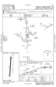
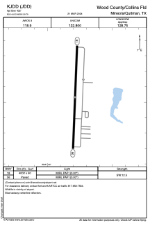


KJDD - Wood County/Collins Fld
Located in Mineola/Quitman, United States
ICAO - JDD, IATA -
Data provided by AirmateGeneral information
Coordinates: N32°44'32" W95°29'47"
Elevation is 432 feet MSL.
Magnetic variation is 02° East View others Airports in Texas
Operational data
Special qualification required
Current time UTC:
Current local time:
Communications frequencies: [VIEW]
Runways:
| RWY identifier | QFU | Length (ft) | Width (ft) | Surface | LDA (ft) |
| 18 | 182° | 4002 | 60 | ASPH | |
| 36 | 2° | 4002 | 60 | ASPH |
Airport contact information
Address: Mineola/Quitman United States
