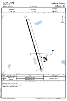


KJCA - Jackson County
Located in Jefferson, United States
ICAO - JCA, IATA -
Data provided by AirmateGeneral information
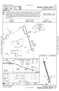
Coordinates: N34°10'34" W83°33'42"
Elevation is 950 feet MSL.
Magnetic variation is -05° East View others Airports in Georgia
Operational data
Special qualification required
Current time UTC:
Current local time:
Weather
METAR: KJCA 241335Z AUTO 27007KT 10SM OVC070 15/10 A3011 RMK AO2 T01500102
Communications frequencies: [VIEW]
Runways:
| RWY identifier | QFU | Length (ft) | Width (ft) | Surface | LDA (ft) |
| 17 | 163° | 5010 | 75 | ASPH | |
| 35 | 343° | 5010 | 75 | ASPH |
Airport contact information
Address: Jefferson United States