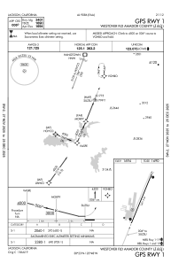


KJAQ - Westover Fld Amador County
Located in Jackson, United States
ICAO - JAQ, IATA -
Data provided by AirmateGeneral information
Coordinates: N38°22'36" W120°47'38"
Elevation is 1693 feet MSL.
Magnetic variation is 16° East View others Airports in California
Operational data
Special qualification required
Current time UTC:
Current local time:
Weather
METAR: KJAQ 180855Z AUTO 00000KT 10SM CLR 14/14 A2998 RMK AO1 T01420140
Communications frequencies: [VIEW]
Runways:
| RWY identifier | QFU | Length (ft) | Width (ft) | Surface | LDA (ft) |
| 01 | 22° | 3401 | 60 | ASPH | |
| 19 | 202° | 3401 | 60 | ASPH |
Airport contact information
Address: Jackson United States