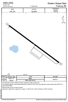


KIZG - Eastern Slopes Rgnl
Located in Fryeburg, United States
ICAO - IZG, IATA - FRY
Data provided by AirmateGeneral information
Coordinates: N43°59'28" W70°56'52"
Elevation is 454 feet MSL.
Magnetic variation is -17° East View others Airports in Maine
Operational data
Special qualification required
Current time UTC:
Current local time:
Communications frequencies: [VIEW]
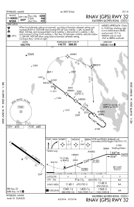
Runways:
| RWY identifier | QFU | Length (ft) | Width (ft) | Surface | LDA (ft) |
| 14 | 126° | 4200 | 75 | ASPH | |
| 32 | 306° | 4200 | 75 | ASPH |
Airport contact information
Address: Fryeburg United States