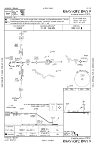
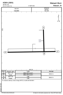


KIWH - Wabash Muni
Located in Wabash, United States
ICAO - IWH, IATA -
Data provided by AirmateGeneral information
Coordinates: N40°45'43" W85°47'56"
Elevation is 795 feet MSL.
Magnetic variation is -03° East View others Airports in Indiana
Operational data
Special qualification required
Current time UTC:
Current local time:
Communications frequencies: [VIEW]
Runways:
| RWY identifier | QFU | Length (ft) | Width (ft) | Surface | LDA (ft) |
| 09 | 89° | 4401 | 75 | CONC | |
| 27 | 269° | 4401 | 75 | CONC | |
| 18 | 179° | 1940 | 60 | ASPH | |
| 36 | 359° | 1940 | 60 | ASPH |
Airport contact information
Address: Wabash United States
