


KINS - Creech Afb
Located in Indian Springs, United States
ICAO - INS, IATA - INS
Data provided by AirmateGeneral information
Coordinates: N36°35'11" W115°40'39"
Elevation is 3134 feet MSL.
Magnetic variation is 15° East View others Airports in Nevada
Operational data
Special qualification required
Current time UTC:
Current local time:
Weather
METAR: KINS 270355Z AUTO 17003KT 10SM FEW060 BKN080 BKN090 BKN110 OVC150 12/06 A2975 RMK AO2 RAB0256E34 SLP050 P0005 T01240060 $
TAF: TAF AMD KINS 261630Z 2616/2719 VRB06KT 9000 -SHRA BKN050 610509 QNH2970INS BECMG 2617/2618 31012G18KT 9000 -SHRA BKN050 610509 QNH2968INS TEMPO 2618/2621 VRB20G31KT 8000 -TSRA BKN050CB 520009 BECMG 2620/2621 29020G33KT 9999 NSW BKN080 610809 520009 QNH2959INS TS OMTNS BECMG 2701/2702 33015G25KT 9999 VCSH OVC080 610809 520009 QNH2962INS TS OMTNS BECMG 2705/2706 30012KT 9999 VCSH BKN080 610809 QNH2968INS SHRA OMTNS BECMG 2710/2711 28010G15KT 9999 NSW SCT080 QNH2974INS BECMG 2715/2716 31012G18KT 9999 FEW080 QNH2981INS TX19/2622Z TN10/2713Z LAST NO AMDS AFT 2617 NEXT 2905
Communications frequencies: [VIEW]
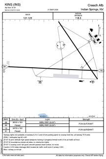
Runways:
| RWY identifier | QFU | Length (ft) | Width (ft) | Surface | LDA (ft) |
| 08 | 93° | 9002 | 150 | ASPH | |
| 26 | 273° | 9002 | 150 | ASPH | |
| 13 | 0° | 5476 | 100 | ASPH | |
| 31 | 0° | 5476 | 100 | ASPH |
Airport contact information
Address: Indian Springs United States