


KIFP - Laughlin/Bullhead Intl
Located in Bullhead City, United States
ICAO - IFP, IATA - IFP
Data provided by AirmateGeneral information
Coordinates: N35°9'17" W114°33'34"
Elevation is 707 feet MSL.
Magnetic variation is 12° East View others Airports in Arizona
Operational data
Special qualification required
Current time UTC:
Current local time:
Weather
METAR: KIFP 261255Z AUTO 22007KT 10SM CLR 17/03 A2972 RMK AO2
TAF: KIFP 261128Z 2612/2712 19008KT P6SM SCT200 FM261600 19011G18KT P6SM SCT080 FM262100 35015G25KT P6SM VCSH SCT070 BKN110 PROB30 2621/2703 VRB20G30KT 5SM -TSRA BKN070CB FM270300 14010KT P6SM VCSH BKN100 FM270900 16006KT P6SM SCT100
Communications frequencies: [VIEW]
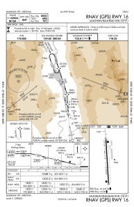
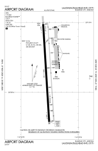
Runways:
| RWY identifier | QFU | Length (ft) | Width (ft) | Surface | LDA (ft) |
| 16 | 176° | 8501 | 150 | ASPH | 8500 |
| 34 | 356° | 8501 | 150 | ASPH | 8500 |
Airport contact information
Address: Bullhead City United States