


KIAH - George Bush Intcntl/Houston
Located in Houston, United States
ICAO - IAH, IATA - IAH
Data provided by AirmateGeneral information
Coordinates: N29°59'4" W95°20'29"
Elevation is 95 feet MSL.
Magnetic variation is 03° East View others Airports in Texas
Operational data
Special qualification required
Current time UTC:
Current local time:
Weather
METAR: KIAH 250653Z 18004KT 10SM SCT250 21/19 A3007 RMK AO2 SLP181 T02060189
TAF: KIAH 250520Z 2506/2612 15008KT P6SM BKN250 FM250700 VRB04KT P6SM SCT015 BKN025 FM250900 VRB04KT P6SM SCT007 BKN012 TEMPO 2509/2512 OVC007 FM251600 15010KT P6SM SCT025 BKN035 FM252000 15015G23KT P6SM BKN030
Communications frequencies: [VIEW]
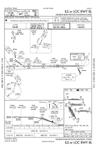
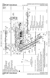
Runways:
| RWY identifier | QFU | Length (ft) | Width (ft) | Surface | LDA (ft) |
| 08R | 90° | 9402 | 150 | CONC | 9402 |
| 26L | 270° | 9402 | 150 | CONC | 9402 |
| 08L | 90° | 9000 | 150 | CONC | 9000 |
| 26R | 270° | 9000 | 150 | CONC | 9000 |
| 09 | 90° | 10000 | 150 | CONC | 10000 |
| 27 | 270° | 10000 | 150 | CONC | 10000 |
| 15R | 152° | 10000 | 150 | CONC | 9999 |
| 33L | 332° | 10000 | 150 | CONC | 9999 |
| 15L | 152° | 12001 | 150 | CONC | 12001 |
| 33R | 332° | 12001 | 150 | CONC | 12001 |
Airport contact information
Address: Houston United States