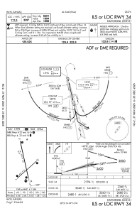
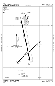


KHYS - Hays Rgnl
Located in Hays, United States
ICAO - HYS, IATA - HYS
Data provided by AirmateGeneral information
Coordinates: N38°50'32" W99°16'23"
Elevation is 1999 feet MSL.
Magnetic variation is 08° East View others Airports in Kansas
Operational data
Special qualification required
Current time UTC:
Current local time:
Weather
METAR: KHYS 251356Z AUTO 14012KT 10SM BKN016 OVC020 17/12 A2987 RMK AO2 RAB33E44 SLP105 P0000 T01720117
TAF: KHYS 251446Z 2515/2612 14012KT P6SM BKN016 OVC020 FM251800 13021G29KT P6SM BKN015 FM260100 15022G31KT P6SM VCTS SCT040CB
Communications frequencies: [VIEW]
Runways:
| RWY identifier | QFU | Length (ft) | Width (ft) | Surface | LDA (ft) |
| 04 | 48° | 4501 | 75 | CONC | 4500 |
| 22 | 228° | 4501 | 75 | CONC | 4500 |
| 16 | 167° | 6501 | 100 | CONC | 6501 |
| 34 | 347° | 6501 | 100 | CONC | 6501 |
Airport contact information
Address: Hays United States
