


KHYA - Cape Cod Gateway
Located in Hyannis, United States
ICAO - HYA, IATA - HYA
Data provided by AirmateGeneral information
Coordinates: N41°40'10" W70°16'49"
Elevation is 54 feet MSL.
Magnetic variation is -16° East View others Airports in Massachusetts
Operational data
Special qualification required
Current time UTC:
Current local time:
Weather
METAR: KHYA 290756Z AUTO 28006KT 10SM CLR 16/13 A2988 RMK AO2 SLP119 T01560133 $
TAF: KHYA 290537Z 2906/3006 26013KT P6SM SCT050 FM290800 28008KT 2SM BR SCT015 BKN035 FM290900 30007KT 1SM BR SCT010 BKN030 FM291100 35009KT P6SM BKN045 FM291500 01012G21KT P6SM SCT250 FM292100 07006KT P6SM FEW250 FM300000 17004KT P6SM FEW150
Communications frequencies: [VIEW]
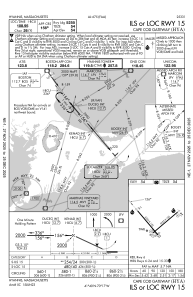
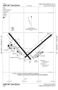
Runways:
| RWY identifier | QFU | Length (ft) | Width (ft) | Surface | LDA (ft) |
| 06 | 50° | 5425 | 150 | ASPH | 5019 |
| 24 | 230° | 5425 | 150 | ASPH | 5425 |
| 15 | 140° | 5255 | 150 | ASPH | 5255 |
| 33 | 320° | 5255 | 150 | ASPH | 5105 |
Airport contact information
Address: Hyannis United States
