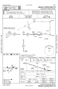
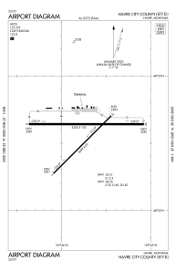


KHVR - Havre City-County
Located in Havre, United States
ICAO - HVR, IATA - HVR
Data provided by AirmateGeneral information
Coordinates: N48°32'35" W109°45'44"
Elevation is 2591 feet MSL.
Magnetic variation is 13° East View others Airports in Montana
Operational data
Special qualification required
Current time UTC:
Current local time:
Weather
METAR: KHVR 011553Z AUTO 23014KT 10SM CLR 07/M01 A2987 RMK AO2 SLP129 T00671006
TAF: KHVR 011136Z 0112/0212 23009KT P6SM SCT080 FM011800 26014G23KT P6SM VCSH SCT060 PROB30 0121/0124 4SM -SHRA BR OVC025 FM020400 30009KT 4SM -SHSNRA BR BKN025
Communications frequencies: [VIEW]
Runways:
| RWY identifier | QFU | Length (ft) | Width (ft) | Surface | LDA (ft) |
| 03 | 45° | 3699 | 60 | ASPH | 3699 |
| 21 | 225° | 3699 | 60 | ASPH | 3699 |
| 08 | 90° | 5205 | 100 | ASPH | 5205 |
| 26 | 270° | 5205 | 100 | ASPH | 5205 |
Airport contact information
Address: Havre United States