


KHRL - Valley Intl
Located in Harlingen, United States
ICAO - HRL, IATA - HRL
Data provided by AirmateGeneral information
Coordinates: N26°13'38" W97°39'19"
Elevation is 36 feet MSL.
Magnetic variation is 05° East View others Airports in Texas
Operational data
Special qualification required
Current time UTC:
Current local time:
Weather
METAR: KHRL 192352Z 11011KT 10SM CLR 28/22 A2985 RMK AO2 SLP107 T02830217 10333 20272 55005
TAF: KHRL 192333Z 2000/2024 14013KT P6SM SCT025 FM200300 12010KT P6SM OVC014 FM200600 14009KT 6SM BR OVC008 FM201500 15010KT P6SM BKN025 FM201700 14014G22KT P6SM BKN035
Communications frequencies: [VIEW]
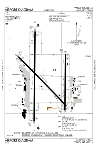
Runways:
| RWY identifier | QFU | Length (ft) | Width (ft) | Surface | LDA (ft) |
| 13 | 136° | 7257 | 150 | ASPH | 7257 |
| 31 | 316° | 7257 | 150 | ASPH | 7257 |
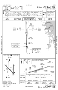
| 17R | 181° | 8301 | 150 | ASPH | 8301 |
| 35L | 1° | 8301 | 150 | ASPH | 8301 |
| 17L | 181° | 5949 | 150 | ASPH | 5949 |
| 35R | 1° | 5949 | 150 | ASPH | 5759 |
Airport contact information
Address: Harlingen United States
