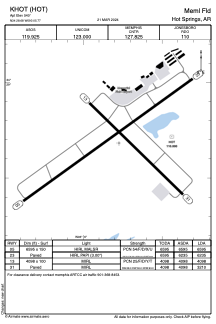


KHOT - Meml Fld
Located in Hot Springs, United States
ICAO - HOT, IATA - HOT
Data provided by AirmateGeneral information
Coordinates: N34°28'41" W93°5'46"
Elevation is 540 feet MSL.
Magnetic variation is 01° East View others Airports in Arkansas
Operational data
Special qualification required
Current time UTC:
Current local time:
Weather
METAR: KHOT 251353Z AUTO 10004KT 10SM OVC017 18/10 A3012 RMK AO2 LTG DSNT NE SLP195 T01780100
TAF: KHOT 251134Z 2512/2612 10006KT P6SM VCSH SCT025 BKN050 TEMPO 2512/2516 5SM -SHRA BR BKN025 FM251600 09006KT 6SM -SHRA BR VCTS OVC025CB TEMPO 2516/2520 3SM -TSRA BR OVC015CB FM252000 10009KT P6SM VCSH BKN025 OVC050 PROB30 2520/2602 4SM -TSRA BR OVC015CB FM260600 13008KT P6SM BKN015 OVC030
Communications frequencies: [VIEW]
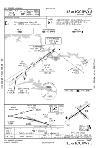
Runways:
| RWY identifier | QFU | Length (ft) | Width (ft) | Surface | LDA (ft) |
| 05 | 54° | 6595 | 150 | ASPH | 6595 |
| 23 | 234° | 6595 | 150 | ASPH | 6235 |
| 13 | 134° | 4098 | 100 | ASPH | 4098 |
| 31 | 314° | 4098 | 100 | ASPH | 3210 |
Airport contact information
Address: Hot Springs United States
