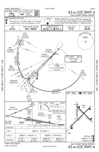
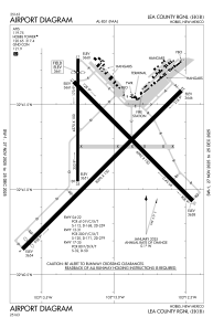


KHOB - Lea County Rgnl
Located in Hobbs, United States
ICAO - HOB, IATA - HOB
Data provided by AirmateGeneral information
Coordinates: N32°41'15" W103°13'2"
Elevation is 3660 feet MSL.
Magnetic variation is 07° East View others Airports in New Mexico
Operational data
Special qualification required
Current time UTC:
Current local time:
Weather
METAR: KHOB 061550Z 23021G30KT 10SM CLR 27/M06 A2980
TAF: KHOB 061153Z 0612/0712 19011KT P6SM BKN008 FM061300 21015G23KT P6SM FEW250 FM061600 25020G30KT P6SM SKC FM070100 26014KT P6SM SKC FM070300 29009KT P6SM SKC
Communications frequencies: [VIEW]
Runways:
| RWY identifier | QFU | Length (ft) | Width (ft) | Surface | LDA (ft) |
| 03 | 45° | 7398 | 150 | ASPH | 7020 |
| 21 | 225° | 7398 | 150 | ASPH | 7398 |
| 12 | 135° | 6002 | 150 | ASPH | 6002 |
| 30 | 315° | 6002 | 150 | ASPH | 6002 |
| 17 | 180° | 4998 | 100 | ASPH | 4506 |
| 35 | 0° | 4998 | 100 | ASPH | 4998 |
Airport contact information
Address: Hobbs United States