


KHNB - Huntingburg
Located in Huntingburg, United States
ICAO - HNB, IATA - HNB
Data provided by AirmateGeneral information
Coordinates: N38°14'56" W86°57'10"
Elevation is 529 feet MSL.
Magnetic variation is -04° East View others Airports in Indiana
Operational data
Special qualification required
Current time UTC:
Current local time:
Weather
TAF: KHNB 232320Z 2400/2424 26010KT 5SM -RA OVC035 TEMPO 2402/2404 4SM -RA BKN028 FM240500 VRB03KT P6SM BKN022 OVC035 FM241300 35008KT P6SM SCT040 AMD NOT SKED 2403/2408
Communications frequencies: [VIEW]
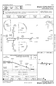
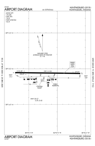
Runways:
| RWY identifier | QFU | Length (ft) | Width (ft) | Surface | LDA (ft) |
| 09 | 91° | 5501 | 100 | ASPH | |
| 27 | 271° | 5501 | 100 | ASPH |
Airport contact information
Address: Huntingburg United States
