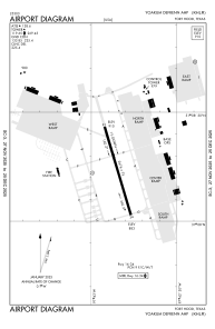


KHLR - Yoakum-Defrenn Ahp
Located in Fort Cavazos (Killeen), United States
ICAO - HLR, IATA - HLR
Data provided by AirmateGeneral information
Coordinates: N31°8'15" W97°42'51"
Elevation is 910 feet MSL.
Magnetic variation is 05° East View others Airports in Texas
Operational data
Special qualification required
Current time UTC:
Current local time:
Weather
METAR: KHLR 301821Z AUTO 19012KT 10SM BKN031 28/21 A2992 RMK AO2 SLP122
Communications frequencies: [VIEW]
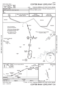
Runways:
| RWY identifier | QFU | Length (ft) | Width (ft) | Surface | LDA (ft) |
| 16 | 164° | 3803 | 144 | ASP | |
| 34 | 344° | 3803 | 144 | ASP |
Airport contact information
Address: Fort Cavazos (Killeen) United States