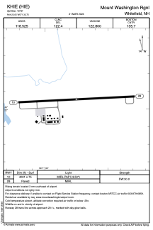


KHIE - Mount Washington Rgnl
Located in Whitefield, United States
ICAO - HIE, IATA -
Data provided by AirmateGeneral information
Coordinates: N44°22'3" W71°32'45"
Elevation is 1072 feet MSL.
Magnetic variation is -17° East View others Airports in New Hampshire
Operational data
Special qualification required
Current time UTC:
Current local time:
Weather
METAR: KHIE 081652Z AUTO 18009G23KT 130V220 10SM BKN060 OVC075 13/07 A2956 RMK AO2 RAB17E36 SLP014 P0000 T01280067
TAF: KHIE 081734Z 0818/0918 16008G18KT P6SM -SHRA OVC050 FM082300 18005KT P6SM -SHRA OVC025 FM090400 36005KT 5SM -SHRA BR OVC008
Communications frequencies: [VIEW]
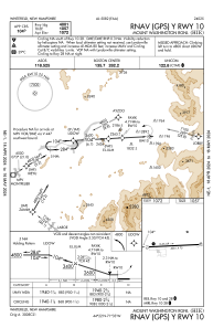
Runways:
| RWY identifier | QFU | Length (ft) | Width (ft) | Surface | LDA (ft) |
| 10 | 87° | 4001 | 75 | ASPH | |
| 28 | 267° | 4001 | 75 | ASPH |
Airport contact information
Address: Whitefield United States
