


KHFF - Mackall Aaf
Located in Camp Mackall, United States
ICAO - HFF, IATA -
Data provided by AirmateGeneral information
Coordinates: N35°2'11" W79°29'51"
Elevation is 376 feet MSL.
Magnetic variation is -09° East View others Airports in North Carolina
Operational data
Special qualification required
Current time UTC:
Current local time:
Weather
METAR: KHFF 252255Z AUTO 07004KT 10SM SCT090 25/08 A3007 RMK AO2 SLP184 T02450080 $
Communications frequencies: [VIEW]
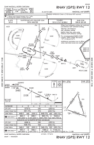
Runways:
| RWY identifier | QFU | Length (ft) | Width (ft) | Surface | LDA (ft) |
| 04 | 35° | 4996 | 100 | ASPH | |
| 22 | 215° | 4996 | 100 | ASPH | |
| 16 | 163° | 5529 | 100 | CONC | |
| 34 | 343° | 5529 | 100 | CONC | |
| 12 | 109° | 4794 | 100 | ASPH | |
| 30 | 289° | 4794 | 100 | ASPH |
Airport contact information
Address: Camp Mackall United States