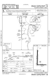
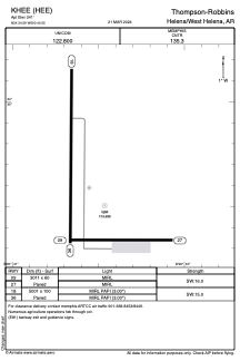


KHEE - Thompson-Robbins
Located in Helena/West Helena, United States
ICAO - HEE, IATA -
Data provided by AirmateGeneral information
Coordinates: N34°34'35" W90°40'33"
Elevation is 241 feet MSL.
Magnetic variation is 01° East View others Airports in Arkansas
Operational data
Special qualification required
Current time UTC:
Current local time:
Weather at : KUTA - Tunica Muni ( 32 km )
METAR: KUTA 250515Z AUTO 04005KT 10SM CLR 13/09 A3015 RMK AO2 T01330085 $
Communications frequencies: [VIEW]
Runways:
| RWY identifier | QFU | Length (ft) | Width (ft) | Surface | LDA (ft) |
| 09 | 90° | 3011 | 60 | ASPH | |
| 27 | 270° | 3011 | 60 | ASPH | |
| 18 | 180° | 5001 | 100 | ASPH | |
| 36 | 0° | 5001 | 100 | ASPH |
Airport contact information
Address: Helena/West Helena United States