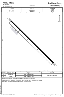


KHBV - Jim Hogg County
Located in Hebbronville, United States
ICAO - HBV, IATA -
Data provided by AirmateGeneral information
Coordinates: N27°20'58" W98°44'13"
Elevation is 662 feet MSL.
Magnetic variation is 06° East View others Airports in Texas
Operational data
Special qualification required
Current time UTC:
Current local time:
Weather
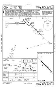
METAR: KHBV 231750Z AUTO 16008KT 10SM BKN016 OVC021 23/19 A3005 RMK AO2 T02290190
Communications frequencies: [VIEW]
Runways:
| RWY identifier | QFU | Length (ft) | Width (ft) | Surface | LDA (ft) |
| 13 | 134° | 5003 | 75 | ASPH | |
| 31 | 314° | 5003 | 75 | ASPH |
Airport contact information
Address: Hebbronville United States