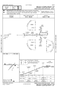
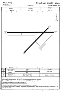


KHAI - Three Rivers Muni/Dr Haines
Located in Three Rivers, United States
ICAO - HAI, IATA - HAI
Data provided by AirmateGeneral information
Coordinates: N41°57'35" W85°35'35"
Elevation is 822 feet MSL.
Magnetic variation is -04° East View others Airports in Michigan
Operational data
Special qualification required
Current time UTC:
Current local time:
Weather
METAR: KHAI 191915Z AUTO 30016G25KT 10SM CLR 11/M05 A3008 RMK AO2 T01051047
Communications frequencies: [VIEW]
Runways:
| RWY identifier | QFU | Length (ft) | Width (ft) | Surface | LDA (ft) |
| 05 | 45° | 2719 | 60 | ASPH | |
| 23 | 225° | 2719 | 60 | ASPH | |
| 09 | 90° | 4000 | 75 | ASPH | |
| 27 | 270° | 4000 | 75 | ASPH |
Airport contact information
Address: Three Rivers United States
