


KGLR - Gaylord Rgnl
Located in Gaylord, United States
ICAO - GLR, IATA - GLR
Data provided by AirmateGeneral information
Coordinates: N45°0'47" W84°42'12"
Elevation is 1328 feet MSL.
Magnetic variation is -06° East View others Airports in Michigan
Operational data
Special qualification required
Current time UTC:
Current local time:
Weather
METAR: KGLR 191553Z AUTO 26017G28KT 10SM FEW047 07/M06 A2988 RMK AO2 PK WND 24028/1459 SLP127 T00721056
Communications frequencies: [VIEW]
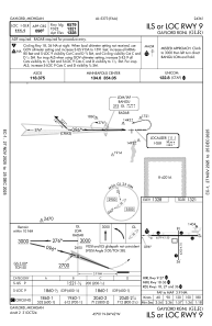
Runways:
| RWY identifier | QFU | Length (ft) | Width (ft) | Surface | LDA (ft) |
| 09 | 90° | 6579 | 150 | ASPH | |
| 27 | 270° | 6579 | 150 | ASPH | |
| 18 | 180° | 4200 | 75 | ASPH | |
| 36 | 0° | 4200 | 75 | ASPH |
Airport contact information
Address: Gaylord United States