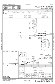
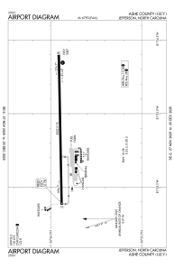


KGEV - Ashe County
Located in Jefferson, United States
ICAO - GEV, IATA -
Data provided by AirmateGeneral information
Coordinates: N36°25'57" W81°25'7"
Elevation is 3177 feet MSL.
Magnetic variation is -07° East View others Airports in North Carolina
Operational data
Special qualification required
Current time UTC:
Current local time:
Communications frequencies: [VIEW]
Runways:
| RWY identifier | QFU | Length (ft) | Width (ft) | Surface | LDA (ft) |
| 10 | 89° | 5002 | 75 | ASPH | |
| 28 | 269° | 5002 | 75 | ASPH |
Airport contact information
Address: Jefferson United States