


KGCD - Grant County Rgnl/Ogilvie Fld
Located in John Day, United States
ICAO - GCD, IATA - JDA
Data provided by AirmateGeneral information
Coordinates: N44°24'11" W118°58'4"
Elevation is 3702 feet MSL.
Magnetic variation is 17° East View others Airports in Oregon
Operational data
Special qualification required
Current time UTC:
Current local time:
Weather
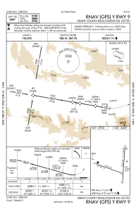
METAR: KGCD 262255Z AUTO 27008KT 10SM SCT048 SCT070 BKN120 08/04 A2986 RMK AO2 P0001 T00780041
Communications frequencies: [VIEW]
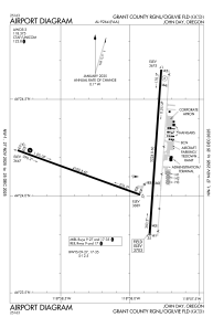
Runways:
| RWY identifier | QFU | Length (ft) | Width (ft) | Surface | LDA (ft) |
| 09 | 110° | 4100 | 60 | ASPH | |
| 27 | 290° | 4100 | 60 | ASPH | |
| 17 | 184° | 5224 | 60 | ASPH | |
| 35 | 4° | 5224 | 60 | ASPH |
Airport contact information
Address: John Day United States