


KGCC - Northeast Wyoming Rgnl
Located in Gillette, United States
ICAO - GCC, IATA - GCC
Data provided by AirmateGeneral information
Coordinates: N44°20'56" W105°32'22"
Elevation is 4365 feet MSL.
Magnetic variation is 09° East View others Airports in Wyoming
Operational data
Special qualification required
Current time UTC:
Current local time:
Weather
METAR: KGCC 072353Z AUTO 31017G33KT 10SM OVC085 07/M01 A2944 RMK AO2 PK WND 32038/2325 SLP965 T00721011 10111 20072 51016
TAF: KGCC 072320Z 0800/0824 30025G35KT P6SM VCSH BKN050 FM080500 29030G47KT P6SM OVC030 FM081000 30022G30KT 5SM -RASN OVC008 FM081500 31022G32KT 5SM -RA OVC008 AMD NOT SKED
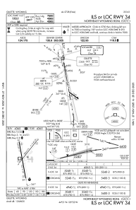
Communications frequencies: [VIEW]
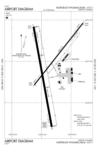
Runways:
| RWY identifier | QFU | Length (ft) | Width (ft) | Surface | LDA (ft) |
| 03 | 38° | 5804 | 75 | CONC | 5803 |
| 21 | 218° | 5804 | 75 | CONC | 5803 |
| 16 | 170° | 7501 | 150 | CONC | 7500 |
| 34 | 350° | 7501 | 150 | CONC | 7500 |
Airport contact information
Address: Gillette United States
