


KFSD - Joe Foss Fld
Located in Sioux Falls, United States
ICAO - FSD, IATA - FSD
Data provided by AirmateGeneral information
Coordinates: N43°34'55" W96°44'31"
Elevation is 1429 feet MSL.
Magnetic variation is 05° East View others Airports in South Dakota
Operational data
Special qualification required
Current time UTC:
Current local time:
Weather
METAR: KFSD 200056Z 14011G21KT 10SM BKN100 BKN150 21/11 A2977 RMK AO2 SLP079 T02110111
TAF: KFSD 192320Z 2000/2024 14010G17KT P6SM BKN120 FM200200 15010KT P6SM VCSH BKN050 FM200600 16008KT P6SM OVC020 FM201100 25006KT P6SM OVC012 FM201400 32006KT P6SM SCT016
Communications frequencies: [VIEW]
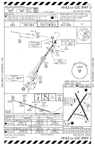
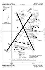
Runways:
| RWY identifier | QFU | Length (ft) | Width (ft) | Surface | LDA (ft) |
| 03 | 35° | 9000 | 150 | CONC | 8999 |
| 21 | 215° | 9000 | 150 | CONC | 8999 |
| 09 | 103° | 3151 | 75 | CONC | |
| 27 | 283° | 3151 | 75 | CONC | |
| 15 | 155° | 8000 | 150 | CONC | 8000 |
| 33 | 335° | 8000 | 150 | CONC | 8000 |
Airport contact information
Address: Sioux Falls United States
