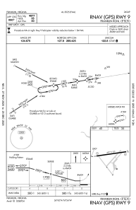
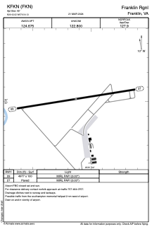


KFKN - Franklin Rgnl
Located in Franklin, United States
ICAO - FKN, IATA - FKN
Data provided by AirmateGeneral information
Coordinates: N36°42'1" W76°54'8"
Elevation is 40 feet MSL.
Magnetic variation is -09° East View others Airports in Virginia
Operational data
Special qualification required
Current time UTC:
Current local time:
Weather
METAR: KFKN 200355Z AUTO 10003KT 10SM OVC019 12/10 A3004 RMK AO2 T01200097
Communications frequencies: [VIEW]
Runways:
| RWY identifier | QFU | Length (ft) | Width (ft) | Surface | LDA (ft) |
| 09 | 81° | 4977 | 100 | ASPH | |
| 27 | 261° | 4977 | 100 | ASPH |
Airport contact information
Address: Franklin United States