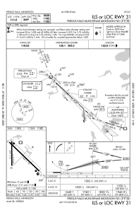


KFFM - Fergus Falls Muni/Einar Mickelson Fld
Located in Fergus Falls, United States
ICAO - FFM, IATA - FFM
Data provided by AirmateGeneral information
Coordinates: N46°17'4" W96°9'24"
Elevation is 1182 feet MSL.
Magnetic variation is 05° East View others Airports in Minnesota
Operational data
Special qualification required
Current time UTC:
Current local time:
Weather
METAR: KFFM 191535Z AUTO 30018G27KT 10SM FEW028 BKN035 OVC043 M01/M07 A3009 RMK AO2
Communications frequencies: [VIEW]
Runways:
| RWY identifier | QFU | Length (ft) | Width (ft) | Surface | LDA (ft) |
| 13 | 133° | 5639 | 100 | ASPH | |
| 31 | 313° | 5639 | 100 | ASPH | |
| 17 | 179° | 3301 | 75 | ASPH | |
| 35 | 359° | 3301 | 75 | ASPH |
Airport contact information
Address: Fergus Falls United States