


KFAF - Felker Aaf
Located in Fort Eustis, United States
ICAO - FAF, IATA - FAF
Data provided by AirmateGeneral information
Coordinates: N37°7'57" W76°36'32"
Elevation is 11 feet MSL.
Magnetic variation is -11° East View others Airports in Virginia
Operational data
Special qualification required
Current time UTC:
Current local time:
Weather
METAR: KFAF 201522Z AUTO 00000KT 10SM BKN008 OVC013 16/14 A2998 RMK AO2 RAB12E13DZB13E21RAB21E22 SLP156 $
Communications frequencies: [VIEW]
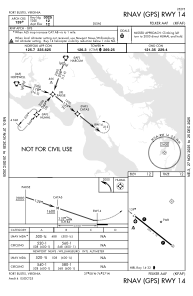
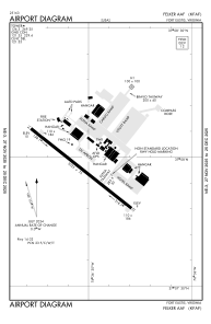
Runways:
| RWY identifier | QFU | Length (ft) | Width (ft) | Surface | LDA (ft) |
| 14 | 0° | 3025 | 75 | ASPH | |
| 32 | 0° | 3025 | 75 | ASPH |
Airport contact information
Address: Fort Eustis United States