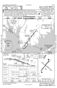
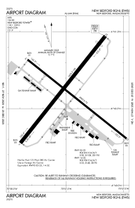


KEWB - New Bedford Rgnl
Located in New Bedford, United States
ICAO - EWB, IATA - EWB
Data provided by AirmateGeneral information
Coordinates: N41°40'36" W70°57'28"
Elevation is 79 feet MSL.
Magnetic variation is -16° East View others Airports in Massachusetts
Operational data
Special qualification required
Current time UTC:
Current local time:
Weather
METAR: KEWB 252053Z 15012G19KT 10SM CLR 09/M02 A3029 RMK AO2 SLP258 T00941022 56006
Communications frequencies: [VIEW]
Runways:
| RWY identifier | QFU | Length (ft) | Width (ft) | Surface | LDA (ft) |
| 05 | 38° | 5400 | 150 | ASPH | |
| 23 | 218° | 5400 | 150 | ASPH | |
| 14 | 128° | 5002 | 75 | ASPH | |
| 32 | 308° | 5002 | 75 | ASPH |
Airport contact information
Address: New Bedford United States
