


KERI - Erie Intl/Tom Ridge Fld
Located in Erie, United States
ICAO - ERI, IATA - ERI
Data provided by AirmateGeneral information
Coordinates: N42°4'59" W80°10'26"
Elevation is 732 feet MSL.
Magnetic variation is -10° East View others Airports in Pennsylvania
Operational data
Special qualification required
Current time UTC:
Current local time:
Weather
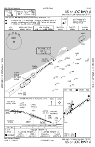
METAR: KERI 270151Z 14005KT 10SM CLR 12/02 A3019 RMK AO2 SLP225 T01220022
TAF: KERI 262330Z 2700/2724 13010G17KT P6SM BKN250 FM270300 15016G27KT P6SM BKN150 FM270800 16021G33KT 6SM -SHRA OVC045 FM271500 17020G32KT 3SM BR OVC017
Communications frequencies: [VIEW]
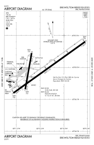
Runways:
| RWY identifier | QFU | Length (ft) | Width (ft) | Surface | LDA (ft) |
| 02 | 10° | 3508 | 150 | ASPH | 2520 |
| 20 | 190° | 3508 | 150 | ASPH | 2902 |
| 06 | 54° | 8420 | 150 | ASPH | 7501 |
| 24 | 234° | 8420 | 150 | ASPH | 7500 |
Airport contact information
Address: Erie United States
