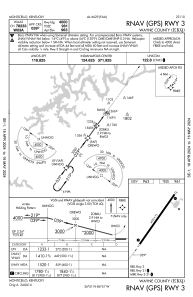


KEKQ - Wayne County
Located in Monticello, United States
ICAO - EKQ, IATA -
Data provided by AirmateGeneral information
Coordinates: N36°51'19" W84°51'22"
Elevation is 962 feet MSL.
Magnetic variation is -03° East View others Airports in Kentucky
Operational data
Special qualification required
Current time UTC:
Current local time:
Weather
METAR: KEKQ 232256Z AUTO 22013KT 10SM CLR 21/02 A3000 RMK AO2 SLP157 T02060017
Communications frequencies: [VIEW]
Runways:
| RWY identifier | QFU | Length (ft) | Width (ft) | Surface | LDA (ft) |
| 03 | 36° | 4000 | 75 | ASPH | |
| 21 | 216° | 4000 | 75 | ASPH |
Airport contact information
Address: Monticello United States