


KEKM - Elkhart Muni
Located in Elkhart, United States
ICAO - EKM, IATA - EKI
Data provided by AirmateGeneral information
Coordinates: N41°43'10" W86°0'12"
Elevation is 777 feet MSL.
Magnetic variation is -04° East View others Airports in Indiana
Operational data
Special qualification required
Current time UTC:
Current local time:
Weather
METAR: KEKM 242235Z 05004KT 10SM BKN031 07/02 A3025 RMK AO2 T00730016 $
Communications frequencies: [VIEW]
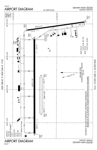
Runways:
| RWY identifier | QFU | Length (ft) | Width (ft) | Surface | LDA (ft) |
| 08 | 89° | 2480 | 250 | GRASS | 2480 |
| 26 | 269° | 2480 | 250 | GRASS | 2480 |
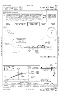
| 09 | 90° | 6500 | 120 | CONC | 6500 |
| 27 | 270° | 6500 | 120 | CONC | 6500 |
| 18 | 172° | 3999 | 75 | ASPH | 4001 |
| 36 | 352° | 3999 | 75 | ASPH | 4001 |
Airport contact information
Address: Elkhart United States