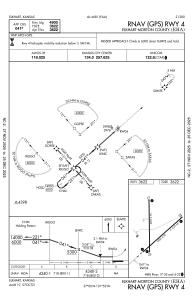


KEHA - Elkhart-Morton County
Located in Elkhart, United States
ICAO - EHA, IATA -
Data provided by AirmateGeneral information
Coordinates: N37°0'3" W101°52'48"
Elevation is 3621 feet MSL.
Magnetic variation is 07° East View others Airports in Kansas
Operational data
Special qualification required
Current time UTC:
Current local time:
Weather
METAR: KEHA 190015Z AUTO 04012KT 10SM CLR 13/00 A3019 RMK AO2 T01280003
Communications frequencies: [VIEW]
Runways:
| RWY identifier | QFU | Length (ft) | Width (ft) | Surface | LDA (ft) |
| 04 | 48° | 4900 | 60 | ASPH | |
| 22 | 228° | 4900 | 60 | ASPH | |
| 17 | 179° | 4907 | 75 | CONC | |
| 35 | 359° | 4907 | 75 | CONC |
Airport contact information
Address: Elkhart United States