


KEDE - Northeastern Rgnl
Located in Edenton, United States
ICAO - EDE, IATA - EDE
Data provided by AirmateGeneral information
Coordinates: N36°1'43" W76°34'11"
Elevation is 18 feet MSL.
Magnetic variation is -10° East View others Airports in North Carolina
Operational data
Special qualification required
Current time UTC:
Current local time:
Weather
METAR: KEDE 201610Z AUTO 26005KT 10SM OVC012 20/19 A3001 RMK AO2 T02030190
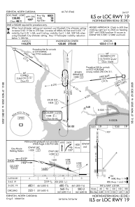
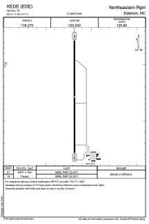
Communications frequencies: [VIEW]
Runways:
| RWY identifier | QFU | Length (ft) | Width (ft) | Surface | LDA (ft) |
| 01 | 0° | 6001 | 100 | ASPH | |
| 19 | 180° | 6001 | 100 | ASPH |
Airport contact information
Address: Edenton United States