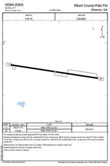


KEBA - Elbert County-Patz Fld
Located in Elberton, United States
ICAO - EBA, IATA -
Data provided by AirmateGeneral information
Coordinates: N34°5'43" W82°49'3"
Elevation is 602 feet MSL.
Magnetic variation is -06° East View others Airports in Georgia
Operational data
Special qualification required
Current time UTC:
Current local time:
Weather
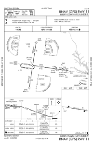
METAR: KEBA 251735Z AUTO 27006KT 10SM CLR 23/08 A3017 RMK AO2 T02290078
Communications frequencies: [VIEW]
Runways:
| RWY identifier | QFU | Length (ft) | Width (ft) | Surface | LDA (ft) |
| 11 | 99° | 5004 | 75 | ASPH | |
| 29 | 279° | 5004 | 75 | ASPH |
Airport contact information
Address: Elberton United States
