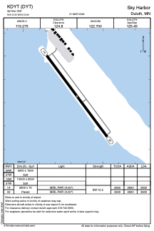


KDYT - Sky Harbor
Located in Duluth, United States
ICAO - DYT, IATA -
Data provided by AirmateGeneral information
Coordinates: N46°43'20" W92°2'40"
Elevation is 608 feet MSL.
Magnetic variation is 01° East View others Airports in Minnesota
Operational data
Special qualification required
Current time UTC:
Current local time:
Weather
METAR: KDYT 201015Z AUTO 26010KT 10SM SCT036 OVC044 00/M05 A3012 RMK AO2
Communications frequencies: [VIEW]
Runways:
| RWY identifier | QFU | Length (ft) | Width (ft) | Surface | LDA (ft) |
| 14 | 143° | 2602 | 75 | ASPH | 2600 |
| 32 | 323° | 2602 | 75 | ASPH | 2600 |
| 09W | 0° | 5000 | 1500 | WATER | |
| 27W | 0° | 5000 | 1500 | WATER | |
| 13W | 0° | 10000 | 2000 | WATER | |
| 31W | 0° | 10000 | 2000 | WATER |
Airport contact information
Address: Duluth United States