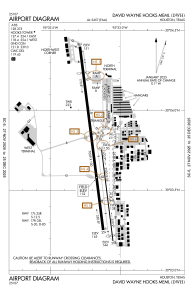


KDWH - David Wayne Hooks Meml
Located in Houston, United States
ICAO - DWH, IATA - DWH
Data provided by AirmateGeneral information
Coordinates: N30°3'42" W95°33'10"
Elevation is 152 feet MSL.
Magnetic variation is 05° East View others Airports in Texas
Operational data
Special qualification required
Current time UTC:
Current local time:
Weather
METAR: KDWH 261753Z 18008G18KT 10SM BKN030 BKN036 26/20 A2987 RMK AO2 SLP112 T02610200 10267 20233 53001
Communications frequencies: [VIEW]
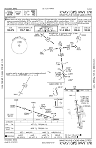
Runways:
| RWY identifier | QFU | Length (ft) | Width (ft) | Surface | LDA (ft) |
| 17R | 173° | 7009 | 100 | ASPH | 6002 |
| 35L | 353° | 7009 | 100 | ASPH | 6700 |
| 17L | 173° | 3500 | 35 | ASPH | |
| 35R | 353° | 3500 | 35 | ASPH | |
| 17W | 0° | 2530 | 100 | WATER | |
| 35W | 0° | 2530 | 100 | WATER |
Airport contact information
Address: Houston United States
Other aviation service providers
Flight schools

Atp Flight School (800-All-Atps)
Atp Flight School (800-All-Atps)
info@atpflightschool.com+1(800)255-2877