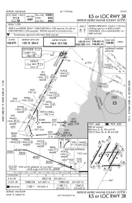
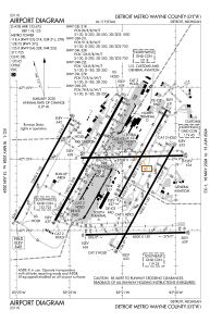


KDTW - Detroit Metro Wayne County
Located in Detroit, United States
ICAO - DTW, IATA - DTW
Data provided by AirmateGeneral information
Coordinates: N42°12'45" W83°21'12"
Elevation is 645 feet MSL.
Magnetic variation is -07° East View others Airports in Michigan
Operational data
Special qualification required
Current time UTC:
Current local time:
Weather
METAR: KDTW 031953Z 21003KT 10SM FEW015 BKN100 BKN150 20/14 A3000 RMK AO2 SLP159 T02000144
TAF: KDTW 031721Z 0318/0424 12006KT P6SM SCT015 BKN070 OVC100 FM032200 10004KT P6SM VCSH SCT035 BKN070 FM040100 04005KT P6SM SCT025 BKN250 FM040600 02004KT 4SM BR SCT007 OVC012 FM041500 08005KT P6SM BKN022 FM041900 13007KT P6SM BKN040
Communications frequencies: [VIEW]
Runways:
| RWY identifier | QFU | Length (ft) | Width (ft) | Surface | LDA (ft) |
| 03L | 29° | 8501 | 150 | CONC | 8501 |
| 21R | 209° | 8501 | 150 | CONC | 8501 |
| 03R | 29° | 10001 | 150 | CONC | 10001 |
| 21L | 209° | 10001 | 150 | CONC | 10001 |
| 04L | 29° | 10000 | 150 | CONC | 10000 |
| 22R | 209° | 10000 | 150 | CONC | 10000 |
| 04R | 29° | 12003 | 200 | CONC | 11494 |
| 22L | 209° | 12003 | 200 | CONC | 12003 |
| 04X | 29° | 0 | 0 | ||
| 22X | 209° | 0 | 0 | ||
| 09L | 89° | 8708 | 150 | CONC | 8618 |
| 27R | 269° | 8708 | 150 | CONC | 8708 |
| 09R | 89° | 8500 | 150 | CONC | 8500 |
| 27L | 269° | 8500 | 150 | CONC | 8500 |
Airport contact information
Address: Detroit United States