


KDLH - Duluth Intl
Located in Duluth, United States
ICAO - DLH, IATA - DLH
Data provided by AirmateGeneral information
Coordinates: N46°50'31" W92°11'36"
Elevation is 1427 feet MSL.
Magnetic variation is -01° East View others Airports in Minnesota
Operational data
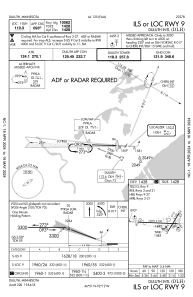
Special qualification required
Current time UTC:
Current local time:
Weather
METAR: KDLH 031112Z 20010KT 1/2SM R09/2000V4500FT -DZ FG VV002 06/05 A2981 RMK AO2 P0000 T00610050
TAF: KDLH 031120Z 0312/0412 20009KT 1/2SM -DZ FG BKN002 TEMPO 0312/0313 1/4SM -DZ FG FM031300 23012G19KT P6SM SKC FM031600 24017G27KT P6SM FEW110 FM040000 25014G21KT P6SM -SHRA BKN070 FM040500 27009KT 6SM -SHRA OVC040 FM041000 28005KT 3SM SHRA BR OVC021
Communications frequencies: [VIEW]
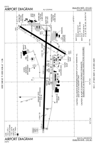
Runways:
| RWY identifier | QFU | Length (ft) | Width (ft) | Surface | LDA (ft) |
| 03 | 32° | 5719 | 150 | ASPH | 5719 |
| 21 | 212° | 5719 | 150 | ASPH | 5719 |
| 09 | 92° | 10591 | 150 | CONC | 10062 |
| 27 | 272° | 10591 | 150 | CONC | 10062 |
Airport contact information
Address: Duluth United States
