


KDEC - Decatur
Located in Decatur, United States
ICAO - DEC, IATA - DEC
Data provided by AirmateGeneral information
Coordinates: N39°50'4" W88°51'56"
Elevation is 681 feet MSL.
Magnetic variation is -01° East View others Airports in Illinois
Operational data
Special qualification required
Current time UTC:
Current local time:
Weather
METAR: KDEC 250454Z AUTO 08006KT 10SM CLR 03/03 A3028 RMK AO2 SLP258 T00330028
TAF: KDEC 242320Z 2500/2524 04008KT P6SM SCT025 FM250100 07006KT P6SM FEW250 FM251400 12009KT P6SM SCT120
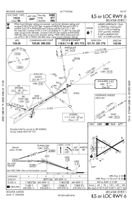
Communications frequencies: [VIEW]
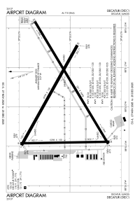
Runways:
| RWY identifier | QFU | Length (ft) | Width (ft) | Surface | LDA (ft) |
| 06 | 59° | 8496 | 150 | OTHER | 8496 |
| 24 | 239° | 8496 | 150 | OTHER | 8496 |
| 12 | 119° | 6799 | 150 | OTHER | 6799 |
| 30 | 299° | 6799 | 150 | OTHER | 6799 |
| 18 | 179° | 5298 | 150 | ASPH | 5298 |
| 36 | 359° | 5298 | 150 | ASPH | 5298 |
Airport contact information
Address: Decatur United States