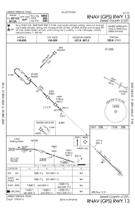
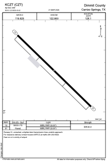


KCZT - Dimmit County
Located in Carrizo Springs, United States
ICAO - CZT, IATA - CZT
Data provided by AirmateGeneral information
Coordinates: N28°31'20" W99°49'25"
Elevation is 598 feet MSL.
Magnetic variation is 07° East View others Airports in Texas
Operational data
Special qualification required
Current time UTC:
Current local time:
Weather
METAR: KCZT 260155Z AUTO 14014G23KT 10SM BKN046 28/20 A2973 RMK AO2
Communications frequencies: [VIEW]
Runways:
| RWY identifier | QFU | Length (ft) | Width (ft) | Surface | LDA (ft) |
| 13 | 134° | 5003 | 75 | ASPH | |
| 31 | 314° | 5003 | 75 | ASPH |
Airport contact information
Address: Carrizo Springs United States