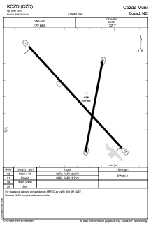


KCZD - Cozad Muni
Located in Cozad, United States
ICAO - CZD, IATA -
Data provided by AirmateGeneral information
Coordinates: N40°52'11" W100°0'15"
Elevation is 2503 feet MSL.
Magnetic variation is 07° East View others Airports in Nebraska
Operational data
Special qualification required
Current time UTC:
Current local time:
Communications frequencies: [VIEW]
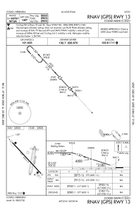
Runways:
| RWY identifier | QFU | Length (ft) | Width (ft) | Surface | LDA (ft) |
| 13 | 137° | 5000 | 75 | CONC | |
| 31 | 317° | 5000 | 75 | CONC | |
| 18 | 191° | 3000 | 300 | GRASS | |
| 36 | 11° | 3000 | 300 | GRASS |
Airport contact information
Address: Cozad United States