


KCYW - Clay Center Muni
Located in Clay Center, United States
ICAO - CYW, IATA -
Data provided by AirmateGeneral information
Coordinates: N39°23'14" W97°9'26"
Elevation is 1208 feet MSL.
Magnetic variation is 04° East View others Airports in Kansas
Operational data
Special qualification required
Current time UTC:
Current local time:
Weather at : KCNK - Blosser Muni ( 46 km )
METAR: KCNK 260055Z AUTO 13023G35KT 10SM OVC026 16/13 A2969 RMK AO2 PK WND 15039/0031 LTG DSNT E RAB33E41 SLP048 P0000 T01560133
Communications frequencies: [VIEW]
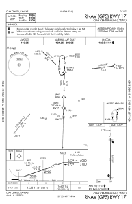
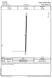
Runways:
| RWY identifier | QFU | Length (ft) | Width (ft) | Surface | LDA (ft) |
| 17 | 181° | 4197 | 75 | ASPH | |
| 35 | 1° | 4197 | 75 | ASPH |
Airport contact information
Address: Clay Center United States