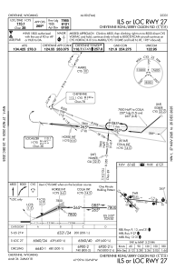
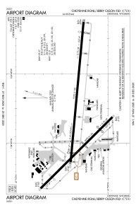


KCYS - Cheyenne Rgnl/Jerry Olson Fld
Located in Cheyenne, United States
ICAO - CYS, IATA - CYS
Data provided by AirmateGeneral information
Coordinates: N41°9'20" W104°48'38"
Elevation is 6159 feet MSL.
Magnetic variation is 10° East View others Airports in Wyoming
Operational data
Special qualification required
Current time UTC:
Current local time:
Weather
METAR: KCYS 070753Z AUTO 28029G42KT 10SM CLR 05/M07 A2957 RMK AO2 PK WND 28048/0740 SLP988 T00501072
TAF: KCYS 070520Z 0706/0806 28030G40KT P6SM SCT200 FM070800 28030G40KT P6SM FEW250 WS020/28055KT FM071200 27025G35KT P6SM FEW250 FM071500 29030G50KT P6SM SCT250
Communications frequencies: [VIEW]
Runways:
| RWY identifier | QFU | Length (ft) | Width (ft) | Surface | LDA (ft) |
| 09 | 95° | 9270 | 150 | CONC | 7985 |
| 27 | 275° | 9270 | 150 | CONC | 7985 |
| 13 | 135° | 6690 | 150 | ASPH | 4830 |
| 31 | 315° | 6690 | 150 | ASPH | 4880 |
Airport contact information
Address: Cheyenne United States
