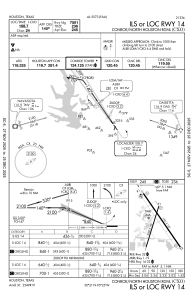
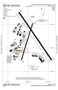


KCXO - Conroe/North Houston Rgnl
Located in Houston, United States
ICAO - CXO, IATA - CXO
Data provided by AirmateGeneral information
Coordinates: N30°21'12" W95°24'54"
Elevation is 244 feet MSL.
Magnetic variation is 05° East View others Airports in Texas
Operational data
Special qualification required
Current time UTC:
Current local time:
Weather
METAR: KCXO 301153Z 00000KT 1/4SM FG VV002 17/17 A2995 RMK AO2 SLP140 T01720172 10194 20156 53012
TAF: KCXO 301124Z 3012/0112 VRB03KT 1SM BR FEW002 BKN040 TEMPO 3012/3014 1/4SM FG BKN002 FM301400 14005KT 6SM BR BKN030 FM301600 15007KT P6SM SCT050 FM010600 VRB04KT P6SM BKN015
Communications frequencies: [VIEW]
Runways:
| RWY identifier | QFU | Length (ft) | Width (ft) | Surface | LDA (ft) |
| 01 | 17° | 5000 | 100 | CONC | 5000 |
| 19 | 197° | 5000 | 100 | CONC | 5000 |
| 14 | 145° | 7501 | 150 | CONC | |
| 32 | 325° | 7501 | 150 | CONC |
Airport contact information
Address: Houston United States
