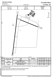


KCVO - Corvallis Muni
Located in Corvallis, United States
ICAO - CVO, IATA - CVO
Data provided by AirmateGeneral information
Coordinates: N44°29'49" W123°17'22"
Elevation is 249 feet MSL.
Magnetic variation is 15° East View others Airports in Oregon
Operational data
Special qualification required
Current time UTC:
Current local time:
Weather
METAR: KCVO 230656Z AUTO 00000KT 10SM CLR 08/03 A2992 RMK AO2 SLP132 T00830028
Communications frequencies: [VIEW]
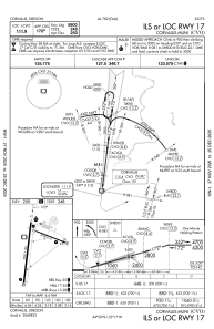
Runways:
| RWY identifier | QFU | Length (ft) | Width (ft) | Surface | LDA (ft) |
| 17 | 187° | 5900 | 150 | ASPH | 5900 |
| 35 | 7° | 5900 | 150 | ASPH | 5900 |
| 10 | 112° | 3100 | 75 | ASPH | 3100 |
| 28 | 292° | 3100 | 75 | ASPH | 2872 |
Airport contact information
Address: Corvallis United States
