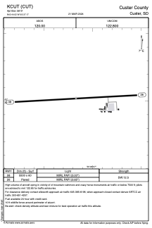


KCUT - Custer County
Located in Custer, United States
ICAO - CUT, IATA -
Data provided by AirmateGeneral information
Coordinates: N43°44'1" W103°37'10"
Elevation is 5619 feet MSL.
Magnetic variation is 11° East View others Airports in South Dakota
Operational data
Special qualification required
Current time UTC:
Current local time:
Weather
METAR: KCUT 232153Z AUTO 11009G19KT 10SM FEW055 10/M03 A3011 RMK AO2 SLP183 T01001033
Communications frequencies: [VIEW]
Runways:
| RWY identifier | QFU | Length (ft) | Width (ft) | Surface | LDA (ft) |
| 08 | 87° | 5500 | 60 | ASPH | |
| 26 | 267° | 5500 | 60 | ASPH |
Airport contact information
Address: Custer United States