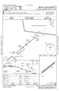
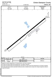


KCTZ - Clinton-Sampson County
Located in Clinton, United States
ICAO - CTZ, IATA - CTZ
Data provided by AirmateGeneral information
Coordinates: N34°58'30" W78°21'56"
Elevation is 144 feet MSL.
Magnetic variation is -09° East View others Airports in North Carolina
Operational data
Special qualification required
Current time UTC:
Current local time:
Weather
METAR: KCTZ 201055Z AUTO 00000KT 1SM OVC002 18/18 A2997 RMK AO2 T01820182
Communications frequencies: [VIEW]
Runways:
| RWY identifier | QFU | Length (ft) | Width (ft) | Surface | LDA (ft) |
| 06 | 51° | 5008 | 75 | ASPH | |
| 24 | 231° | 5008 | 75 | ASPH |
Airport contact information
Address: Clinton United States