


KCSG - Columbus
Located in Columbus, United States
ICAO - CSG, IATA - CSG
Data provided by AirmateGeneral information
Coordinates: N32°30'59" W84°56'20"
Elevation is 397 feet MSL.
Magnetic variation is -02° East View others Airports in Georgia
Operational data
Special qualification required
Current time UTC:
Current local time:
Weather
TAF: KCSG 252339Z 2600/2624 30004KT P6SM SCT250 FM260700 10003KT P6SM BKN100 FM261700 11008KT P6SM SCT050 BKN100 FM262100 09010KT P6SM OVC100
Communications frequencies: [VIEW]
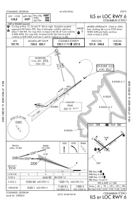
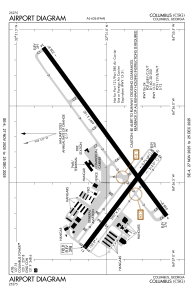
Runways:
| RWY identifier | QFU | Length (ft) | Width (ft) | Surface | LDA (ft) |
| 06 | 54° | 6997 | 150 | ASPH | 6997 |
| 24 | 234° | 6997 | 150 | ASPH | 6997 |
| 13 | 127° | 3997 | 75 | ASPH | 3997 |
| 31 | 307° | 3997 | 75 | ASPH | 3997 |
Airport contact information
Address: Columbus United States
